

As KiwiRail enters talks to terminate plans for its new Interislander ferries, transport planner Nicolas Reid explores the feasibility of other options to link the North and South Islands


The first question to ask is why would we even want a fixed link between the islands – what are the reasons we might have to replace the interislander ferry?
It’s important to note we’re not starting from scratch as ferries already link the islands. The benefit of a crossing doesn’t come from the act linking the two halves of New Zealand together, but how much it improves on the existing connection. So this is basically another way of asking “what are the limitations of the ferries?”
What could a Cook strait crossing do?
There are effectively three ways a fixed link across Cook Strait could improve on the ferries. These are the same three reasons that underline the case for just about any transport infrastructure project: travel time, reliability, capacity. In short, the Cook Strait ferry is fairly slow, it is subject to regular cancellations from weather and equipment failures, and these two combined with the fixed schedule of sailings limits the capacity and dependability of the link. To cover the 65km Wellington and Picton, as the crow flies, takes around four and a half hours including check in and loading time. That’s an effective speed of just 15km/h.
In comparison, a fixed crossing would theoretically be immune to weather conditions and much less susceptible to catastrophic equipment or vehicle failures, and without a fixed schedule and long turnaround times it would have far higher capacity to move vehicles, hour by hour around the clock. Perhaps most significantly the travel time would be vastly reduced, to around 40 minutes between Picton and Wellington.
Ok, so it would certainly be viable from a benefits perspective… but what about the practicality and cost side of the equation? What would the infrastructure to get a fixed link across Cook Strait actually look like? Let’s block out the main constraints and see how that shapes the design.
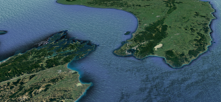
The major obstacles to linking the North and South islands
The biggest problem with the strait is that it’s deep, really deep. There is a trench through the middle of the strait which drops to over 220m below sea level. The second problem is that it is wide. At the narrowest point it’s 22km across, but that’s between the North Island and a point on Arapaoa island, one of the long and mountainous islands of the Marlborough sounds which is quite remote from any towns, roads or railways. The more practical crossing point from Cape Terawhiti on the Wellington side to Oyster Bay on the mainland is more like 30km across. The third problem with crossing the strait is that it is geographically remote and subject to some truly exceptional terrain. On either side the nearest highways and railways are some 15 to 20km away across rugged mountains, valleys and inlets, with barely a dirt road on either side.
A bridge is infeasible
The first thing we can see from this is that any crossing of the strait would have to be a tunnel, not a bridge. The crossing is just too wide, and more importantly too deep, for a bridge. It’s true there are a lot of so-called bridges that span distances across water of twenty kilometres or more, for example the bridge section of the Hong Kong-Macau link, the bridge across Qingdao bay, the crossing between Crimea and Russia or the causeway from Sadi Arabia to Bahrain. The Lake Pontchartrain bridge in Louisiana claims to be the longest bridge over water in the world, covering 38km. This seems more than enough for our purposes. However, these are perhaps more appropriately called elevated causeways or perhaps over-water viaducts rather than bridges. The difference here is that all of these superlong crossings are of relatively shallow waters, which enables them to be supported by from below on rows of piles. The have only one or two modest sections of true bridge to allow a navigation span for larger vessels. This approach is infeasible on Cook Strait however, as the supports would need to be over 200m deep to reach the seafloor, requiring hundreds of submarine structures rivalling the Skytower in height.
Currently the longest true bridges are the great suspension bridges to Shikoku Island in Japan and across the Dardanelles in Turkey. They both have a suspended span of around two kilometres between supports, a fraction of the distance over the Cook Strait trench.
I should note there are some proposals currently for floating bridges, where the suspension towers are built on top of submerged floating chambers that are anchored to the sea floor, similar to deep sea oil rigs. This has the promise of allowing bridges to be built of almost any length across great depths, however nobody has ever built one and they remain just an interesting idea.
But a tunnel is doable… for trains
So a bridge, a causeway or bridge-tunnel combo is infeasible, but surprisingly a tunnel alone isn’t. The longest underwater tunnels in the world are greater than we would need to cross the strait. For example, the Seikan Tunnel between Honshu and Hokkaido in Japan and the Channel Tunnel between England and France are both around 50km long, with underwater sections of 23km and 37km length respectively. More importantly, they are both quite deep, especially the Seikan Tunnel which dives to 240m below sea level. Furthermore, the Japanese example crosses a tectonic fault line with difficult geology, something that a Cook Strait tunnel would also need to do. In short, for thirty-five years the Japan has had an transoceanic tunnel that is longer and deeper than the one that would be required to pass under Cook Strait.
One thing to note here is that all the very long underwater tunnels are rail tunnels rather than road tunnels. This is due to the smaller cross section required for rail, the higher capacity it provides, the lower ventilation requirements and the greater safety against crashes, fires and other emergency situations. The longest subsea road tunnel in the world is the recently opened Ryfylke Tunnel in Norway. While this is also a very deep tunnel to get under a fjord, at 14km long it’s not nearly long enough. Sure it might be technically possible to build a road tunnel long enough to cross the Cook Strait, but it would be twice as long as the longest road tunnel ever built so far, and possibly the deepest. In my book that puts it into the infeasible territory, at least infeasibly risky and expensive to be considered a viable concept.
So a rail tunnel is the most feasible option then. My guestimate, without knowing much about the tunnelling geology, is that the best alignment for a Cook Strait tunnel would between Makara in the hills above Wellington to the valley behind Oyster Bay to the east of Picton. This avoids the deepest part of the trench and the worst of the landside geography, and it also avoids the power cables that run along the sea floor.
This is no mean feat, at 37km long this tunnel is quite a bit longer than just the 28km underwater section. In addition, there would need to be new rail lines extended from the end of the lines on either island. Given the mountainous terrain these rail extensions to the tunnel proper would require some heavy engineering, with numerous smaller tunnels, viaducts and a lot of cut and fill.

Overall, the total route would be about 65km between the railheads of the North and South island networks. Assuming the new crossing was designed for trains going up to 110km/h, the current upper limit for the main trunk lines, it would take about 40 minutes for a train to run between Picton and Wellington.
The new tunnel would be double tracked for capacity and resilience, and it would need to be electrified to remove the risks of diesel trains in such a long tunnel. Therefore, the project should also probably include electrification of the remaining parts of the North Island Main Trunk line, and possibly also the South Island trunk as far as Christchurch.
The road-on-rail shuttle
Even though it would be rail tunnel it would work for cars and trucks too, joining both sides of State Highway 1. This would work by using shuttle trains which road vehicles are loaded onto, which is how the Channel Tunnel operates. Therefore, tunnel would also need an extra-large loading gauge to allow trucks to be driven straight onto oversized rail carriers, at shuttle terminals either side. These would probably be at or near the current ferry terminals at Picton and Wellington, and have a pretty similar operation. The tunnel would effectively operate as a train ferry, with cars and trucks loaded on and off either side of the strait. It’s probably that a dual gauge tracks between the shuttle terminals might be required to allow for oversized shuttle trains on standard gauge as well as regular freight and passenger trains on narrow gauge to use the tunnel. Japan’s Seikan tunnel does this, mixing standard gauge passenger trains with narrow gauge freight trains.
For road transport there would still be loading and unloading time but the crossing would be about three hours faster overall, taking about 90 minutes all up. Also, the shuttle trains could be a lot more regular than the ferries, departing a couple of times an hour rather than a few times per day.
Sounds great, but how much?
Here’s the rub, planning and designing without considering cost as the primary factor is just daydreaming. A Cook Strait tunnel might be a feasible concept in a technical sense, and it might produce a whole lot of benefits over the current ferries…. But whether it’s a good idea depends on whether you can afford it in the first place, and whether the cost of gaining those benefits.
With the Seikan and Channel tunnels we have two good examples of tunnelling projects with similar size and scale that can give us an estimate of the cost involved in crossing Cook Strait. The Japanese tunnel cost ¥1.1 trillion in 1988 while the Anglo-French crossing cost £9 billion in 1994, both of which were massively over budget by the time they were finished. Converting the cost of those projects into today’s dollars gives us an indicative cost in the order of $40 to $50 billion New Zealand dollars, before inevitable delays and blowouts could stretch it far higher. At about 10% of the country’s GDP the concept is improbably expensive and would be practically impossible to fund and deliver. The cost of capital alone would push $2b a year, every year. Even if you could it’s hard to see how a such an extreme cost could stack up even with generous time savings and other benefits.
To sum up a bridge or a road tunnel across Cook Strait would be infeasible, but actually a rail tunnel carrying passenger and freight trains and shuttles for cars and trucks would be possible. At 37km it wouldn’t be the longest transport tunnel in the world, nor the deepest at 200m below sea level, but it would be close on both counts. It would deliver some pretty big time savings, with hours saved compared to the ferries, and it would provide greater capacity, flexibility and reliability to the national transport network.
However, just because it’s technically feasible and provides benefits doesn’t make it a good idea, because the cost of getting those benefits would be enormous. The travel time and resilience benefits wouldn’t come close to exceeding the $50b or so it would cost to build a Cook Strait tunnel, and the amount of international borrowing required to fund it would amount to a threat to our national sovereignty. And if we did have that sort of money to spend on transportation in the country, there are a lot of other things we should be doing first with better returns on investment.
Nicolas Reid is a Principal Public Transport Planner at MRCagney.


