

The Independent Hearings Panel appointed to receive public feedback on the Auckland Council’s landmark ‘Unitary Plan’ has delivered its recommendations to the council – and the results are mixed
Rising to the housing crisis, the panel have unleashed a vast amount of capacity for new housing within the region. This additional capacity is sorely needed and is most welcome, but the panel’s recommended plan, like the Proposed Unitary Plan it was given three years ago, fails to integrate land use and transport and will permanently exacerbate already chronic congestion problems in our largest city.
The council now has just a few weeks to review thousands of pages of content and either agree with or reject the panel’s proposals. The prospects for a land use plan which supports, instead of undermines, transport objectives are highly unlikely.
Just why the Unitary Plan, in any of its current forms, is so much a part of Auckland’s congestion problem, and not part of the solution, is documented in a very important parallel process currently underway.
The Auckland Transport Alignment Project (ATAP) is a joint initiative between the government and an Auckland Council group to improve transport outcomes for the region. It was launched in response to successive analyses indicating Auckland was heading for a congestion meltdown in around a decade.
ATAP has completed two reports with a third and final report due in August. The final report will obviously be the most important, but information included in the first two papers says something very significant about Auckland’s long-term strategic direction.
Far from addressing Auckland’s long standing and vexing transport problems, the Auckland Plan framework sees them get much worse.
It’s important to underscore just how poor these findings are. Within a decade – probably sooner – Auckland traffic speeds on State Highway 1 between Otahuhu and Albany will barely exceed 30km per hour at any point in time between 7am in the morning and 6pm at night, five days a week. Saturdays will almost certainly be as bad, but are not modelled, and weekday peaks will begin before the 7am and finish after the 6pm modelled timeframes.
By 2046, the entire motorway network is planned to be in gridlock all day, every day. Alarmingly, results could actually be a lot worse. ATAP modelling assumes an additional $12 billion of transport investment takes place, which currently is unfunded.
These results are unacceptable for the Auckland economy and for liveability. Luckily, the ATAP group is aware of the issue and is working hard to address the problem.
However, even by reprioritising projects, increasing public transport, increasing road investment and spending even more, ATAP has been unable to significantly improve either congestion or public transport patronage.
The one initiative which analysis shows will have an impact is road pricing. This is something of a breakthrough because decision makers have avoided direct charging of roads by time of day for many years, despite the obvious efficiency and equity benefits which come from user pays.
The problem is that, in order to achieve the mode shift required to mitigate congestion and increase public transport, prices have to be set at an extremely high level. Even then, the projections are that congestion levels will simply remain at around today’s levels, which are extremely high relative to international comparators and unacceptable to the public.
What on earth is going on? Yes, the city is growing, but it has always grown. Yes, its centre is concentrated on a peculiarly shaped isthmus, but it has always been located here.
Yes, the city has underinvested in transport in the past, but transport spending has quadrupled in the past decade and is expected to remain at this level indefinitely. Furthermore, and as noted above, throwing even more money at the problem, public transport, roading or both, does not deliver a benefit consistent with cost.
How can this all be? Results appear counterintuitive, if not contradictory. Why is new investment not having an impact? How can we have worsening congestion without a net public transport mode shift? How can improvements not stack up if traffic is gridlocked?
Problem plan
Something is obviously very wrong with Auckland’s transport situation. That problem is the Unitary Plan.
The need for and desire to travel is determined, above all, by land use. Where jobs are located in relation to housing and where schools are situated are primary determinants of travel demand. Where roads and public transport go and how much land is committed to transport corridors determines the capacity of transport systems to serve that demand.
The more workers have to travel to get to employment, the more pressure there is on transport services – particularly in mornings and evenings. Roads which are four lanes wide carry twice as much traffic as roads which are two lanes wide. Dense commercial development around public transport nodes facilitates public transport use, industrial employment on the periphery will necessitate road investment.
These are basic precepts of integrated land use and transport planning and investment. Unfortunately, the process by which the Auckland Plan, the Long Term Plan, the Regional Land Transport Plan and now the Unitary Plan have been developed has disaggregated the single land use-transport system and the result is predictable.
The unitary plan (both the council’s proposed and the panel’s recommended) intensifies parts of Auckland where there is not the transport capacity to intensify, while areas with transport and access to employment and services incur development restrictions. Homes are permitted miles from jobs, while commercial development is prevented closer to homes.
And our transport system cannot cope.
Limited, if improving, public transport services do not take people all the places they want to go. Services are largely focused on getting workers to and from the central city, but what about commercial trips, school trips, recreational trips and the 75 per cent of jobs outside the CBD and fringe?
Those trips overwhelmingly need private vehicles because their distributed nature undermines the efficiency advantages of public transport. Yet our road system remains hopelessly inadequate to meet this demand.
Far from Auckland being the sprawling, motorway-centric, private vehicle paradise once claimed, we now know that Auckland has an unusually low and grossly insufficient road system spread over a comparatively dense urban area.
The following below contrasts Auckland’s provision of land for movement inside the central city and wider urban area. Auckland has reserved the second-least amount of space for movement of all cities evaluated. Only the infamously congested Moscow has provided less land across the inner core.
Broadly comparable cities like Melbourne and Toronto, meanwhile, have reserved as much as one and a half times more land to footpaths, roads, cycleways and busways across the urban area as Auckland.
Land allocated to streets in cities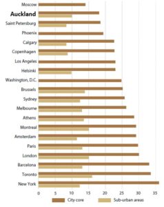
This fundamental under-provision of space for movement combined with more people is the reason why Auckland is clogging up. The city simply does not have the core infrastructure network in place to accommodate the additional trips generated by more people and more businesses within the existing urban area. While reducing private vehicle trips per person, density is increasing private vehicle trips in aggregate, and the network is failing under the pressure.
This is clearly not sustainable, yet from a transport perspective it is presently very difficult to see a way out. This is no doubt why a good proportion of transport experts have thrown their lot in with higher road charges, while others have taken a more “fingers crossed future technology can save us” approach.
However, by shifting focus away from transport, we might actually have a better chance of resolving transport’s toughest problems. It is too late to change the development provisions in what will be by the time this article is published an operational Unitary Plan, but policies and investments which channel development away from the city’s congested urban area may provide some relief.
Distributed density is at the core of the problem. But if we were to concentrate high density, mixed use intensification in greenfield locations adjacent to existing and potential new transport corridors, this would create an opportunity to design a city that offers high amenity and live, walk, work and play options for future generations. I’ll canvas some of these options in a future article.
Hamish Glenn is Senior Policy Advisor at the New Zealand Council for Infrastructure Development (NZCID)


