

University of Canterbury quake experts are contributing to the large science and research response to the 7.5m earthquake both in north Canterbury and Wellington to better understand what has happened and why.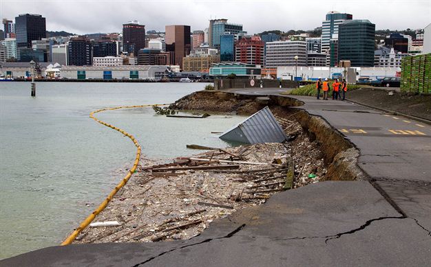
UC Geoscientists, Engineers, Disaster Impact and Social Science researchers are working with GNS Science, NIWA, QuakeCore, National Hazards Research Platform, National Science Challenge, the University of Auckland, and other institutes and colleagues, in a large coordinated science response.
Senior Lecturer in Disaster Risk and Resilience, Dr Tom Wilson of UC Geological Sciences, says that efforts at this stage are focused on mapping where the fault has ruptured at the surface, the extent and location of liquefaction and landslides – particularly those in river valleys which may have dammed rivers, damage to infrastructure, and damage to buildings. A team is also investigating tsunami inundation on Banks Peninsula.
A lot of this work has been carried out by helicopters so far, but field teams are beginning to head out to accessible areas, he says.
“At this stage we are much like everyone else – just trying to make sense of the extent and severity of the impacts, and assess what future issues might be.
“For example, we are trying to assess what further impact aftershocks may have in creating further landslides or infrastructure damage, the economic impacts of transport routes being disrupted, and identify where research contributions could help inform the emergency response and, in particular, help with a rapid and resilient recovery,” Wilson adds.
“Where possible we are working with Emergency Management and feeding information to them to help with managing this disaster.”
UC has also more than 30 postgraduate students joining the research response from across Geological Sciences and Civil Engineering programmes.
“As an example, my own students from the Disaster Risk and Resilience programme are involved in all sorts of aspects, with some about to head out into the field to map faults and landslides, some working with satellite imagery mapping damage, some considering human behaviour response, and others are working directly with Civil Defence and Emergency Management.”
UC civil engineers will be directly involved in assessing bridges and key buildings, and geotechnical response in the affected area with a particular focus around the critically important road and rail infrastructure.
The event has again demonstrated New Zealand’s critical reliance on road, rail and electricity networks, which stretch across our hazardous landscape, he says.
“Due to our country’s long, thin geography and small population, we often have few alternative routes or systems. So when a major part of a network is disrupted, such as State Highway 1 around Kaikoura, our networks can be badly disrupted which isolates communities and impact supply chains, such as all the goods moved by roads.”
Ensuring we learn from this event to increase resilience to these networks is a priority for New Zealand, Wilson insists. “In many parts of New Zealand there are long stretches of infrastructure vulnerable to natural hazards. Ensuring this infrastructure can sustain impacts like earthquakes and landslides and remain functional, or there are functional alternatives is key.”
While Science and Engineering would seem obvious disciplines to be involved in natural disaster response, there are experts offering help from across the entire University.
For example, UC psychologist Professor Julia Rucklidge has commented on “re-traumatising” effects for Cantabrians and mental health issues post-quake, while Engineering and Structural Geology Professor Jarg Pettinga has been flying over quake-affected areas of North Canterbury and South Marlborough to assess the seismic impacts on the areas. Renowned quake expert and QuakeCore deputy director Professor Brendon Bradley is flying back from sabbatical for the response.


